
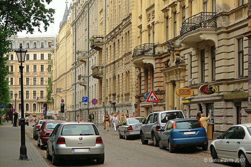
Alberta Street
2007.05.26.
| Area: | 30 370 ha (3) |
| % from area of Latvia: | 0,47 % |
| Population: | 715 978 (4) |
| % of Latvian population: | 31,57% |
| Established: | 1201 |
| Oldest existing building: | Chapel of Riga Order castle - St.George church (1207) |
Most outstanding values
Riga is capital city and largest city of Latvia. Already since the beginning of 13th century the city developed as political and - mainly - economical centre and its importance often extended across the borders of present day Latvia. As for the most part of history Riga was not a centre of independent political power - here are not located imposing complexes of royal castles and parks. But - there were also no special limits to expose the wealth of citizens of Riga and citizens of Riga readily defended their rights often. Thanks to this tradition of civil freedom Riga has got extremly huge number of impressive, ornate buildings - one can estimate that total number of such beautiful buildings in the city exceeds 10 - 12 thousands.
Historical centre of city has been included in the list of UNESCO World Heritage monuments - and as the main value has been declared not so much the comparatively small medieval centre (the only thing seen by most tourists here). As the main values are declared the unusually enormous district of Art Nouveau buildings and the wooden architecture from 19th century. But still here should be mentioned the outstanding medieval churches of Old Riga, especially Dom and St Peter's church.
Outside the historical centre there are located several more suburban historical centres, for example Maskavas forstate, Agenskalns, Tornakalns, Sarkandaugava and others - each of these centres has got quartals of ornate buildings as well. Unusual feature of Riga is former country-estate building and park complexes of the former prosperous families of Rigans from 18th - 19th centuries. There still exist several tens of such country-estates today.
One of the first garden cities of the world whose development started together with the start of the garden city movement in Europe at the end of 19th century is Mezaparks - this neighborhood with hundreds of beautiful mansions and gardens has preserved its spirit up to present day. Nearby in Mezakapi cemetery there is located one of the most outstanding and magnificent Art deco style brethren cemetery complexes of the world. In Bergi neighborhood there is located one of the oldest and largest open-air museums of the world where since 1924 in area of 84 hektares have been located 118 outstanding, ancient wooden buildings from all rural regions of Latvia. One of the most interesting museums is Motormuseum in Mezciems neighborhood where are located several hundreds of vehicles portraying the history of vehicle building since its beginnings.
Division in 58 neighborhoods
Over the last years in Riga City Development Department there is ongoing a process to elaborate a long expected proposal for division of Riga City into smaller neighborhoods. As this division suits very well to the needs of this Website, here are presented the landmarks of Riga City by these neighborhoods. Below this map you will find also an outline table of all 58 neighborhoods.
Choose a neighborhood in the map or in the list below it!
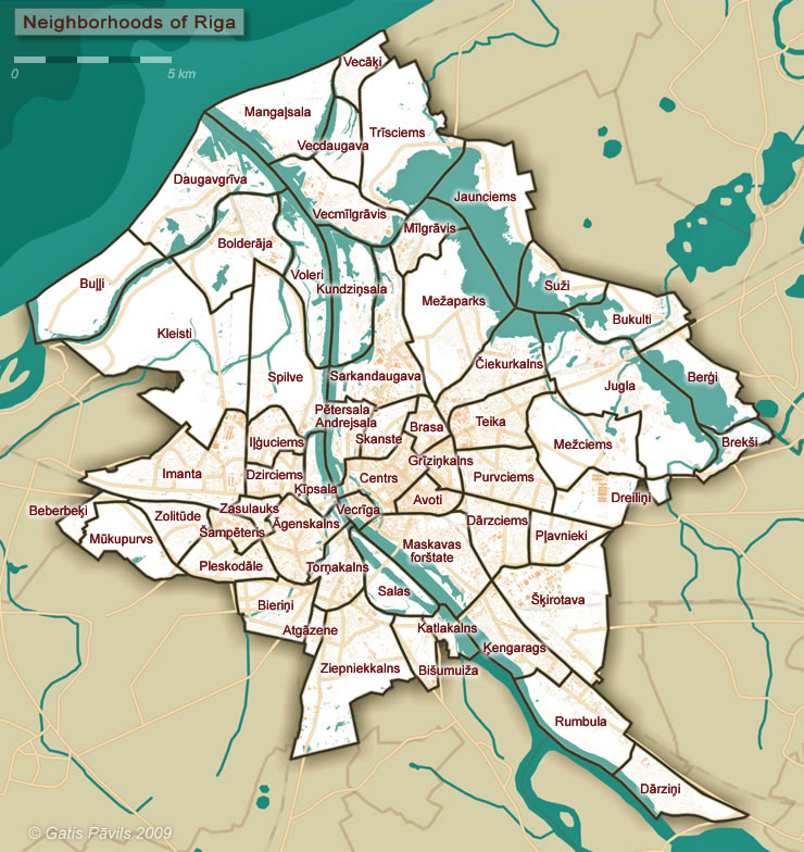
List of neighborhoods of Riga
Data source and changes to original data
This list is based on the data from Riga City Development Department, sources (1) and (2).
As the proposal for the borders and names of neighborhoods at the moment of creation of this table were preliminary, author has brought in some modifications - mainly regarding the borders of neighborhoods. Changes in borders have been done mostly to exclude cases where border goes across a building or where a small part of island is chopped off. Some changes are based on history of the locations - f.e. author has added to Ilguciems the historical factory district which always has been identified with Ilguciems and uses word "Ilguciems" in names of enterprises and institutions up to present day. See further explantions in the column "Remarks" in the table below.
Area
Area includes the area of water bodies. Sea area adjoining Riga is not included in the area of municipality - thus it is not shown here.
Number of inhabitants
Number of inhabitants given here is very approximate, please - don't relay too much on them. Numbers are rounded up to ± 50 inhabitants. Numbers are based on approximate analysis of the number of inhabitants in statistical zones of Riga from 2005 (borders of statistical zones differ from the borders of neighborhoods), shortly analysed earlier demographic tendencies in each statistical zone and very roughly taken into account some of the largest recent apartment building projects.
Use of the table
Each column in this table is sortable by alphabet/numerical size - just click on the header of the table.
| Name | No of monuments described | Approximate No of inhabitants 2008 | Area (ha) | Remarks |
|---|---|---|---|---|
| Agenskalns | 13 | 31 150 | 460,79 | - |
| Atgazene | 2 | 1 050 | 74,4 | - |
| Avoti | 1 | 25 150 | 179,16 | In the source (2) the area is 181,26 ha. If compared to source (2) here the border is adjusted in order not to cross buildings. |
| Beberbeki | 0 | 350 | 120,31 | - |
| Bergi | 2 | 3 000 | 569,97 | - |
| Bierini | 6 | 8 000 | 436,86 | - |
| Bisumuiza | 4 | 2 550 | 224,09 | - |
| Bolderaja | 3 | 14 650 | 795,78 | In the source (2) the area is 831,94 ha. Here excluded northern part of Krievu Island which goes to Voleri. |
| Brasa | 1 | 14 150 | 166,28 | In the source (2) the area is 173,90 ha. If compared to source (2) here the border does not cross buildings and goes along streets instead. Part of area goes to Skanste and to Centrs. |
| Breksi | 2 | 1900 | 203,63 | - |
| Bukulti | 2 | 700 | 517,74 | - |
| Bulli | 1 | 200 | 748,87 | - |
| Centrs | 10 | 38 350 | 383,97 | In the source (2) the area is 373,76 ha. If compared to source (2), here is included part of Brasa in order to place a border along the streets. |
| Ciekurkalns | 7 | 8 250 | 566,33 | - |
| Darzciems | 3 | 21 150 | 418,65 | In the source (2) the area is 457,18 ha. If compared to source (2) here is excluded central prison and Matisa Cemetery which goes to Maskavas forstate. |
| Darzini | 0 | 1 400 | 434,33 | - |
| Daugavgriva | 0 | 9 750 | 1 013,54 | |
| Dreilini | 0 | 2 100 | 415,04 | - |
| Dzirciems | 7 | 13 050 | 239,49 | In the source (2) the area is 244,14 ha. If compared to source (2) here is excluded part south from Tvaikoni Street as it is historically related to place name "Ilguciems" since 18th century at least. |
| Grizinkalns | 2 | 15 100 | 152,68 | In the source (2) the area is 151,56 ha. If compared to source (2) here the border is adjusted in order not to cross buildings. |
| Ilguciems | 4 | 26 250 | 248,60 | In the source (2) the area is 243,94 ha. Here included part of Dzirciems as of source (2) - area south from Tvaikoni Street is historically related to place name "Ilguciems" since 18th century at least. |
| Imanta | 7 | 49 550 | 903,13 | In the source (2) the area is 899,27 ha. Here included the area of garages from Kleisti neighborhood as of source (2) - these garages are accessible and used only by inhabitants of Imanta. |
| Jaunciems | 1 | 2 650 | 912,13 | - |
| Jugla | 16 | 26 850 | 1 408,29 | - |
| Katlakalns | 1 | 150 | 153,80 | In the source (2) the area is 155,20 ha. If compared to source (2) here is excluded part Kazas seklis island - it is part of Salas neighborhood. |
| Kengarags | 2 | 56 500 | 518,37 | - |
| Kipsala | 0 | 900 | 197,23 | - |
| Kleisti | 3 | 150 | 1 866,92 | In the source (2) the area is 1 870,78 ha. Here excluded area of garages which is accessible and used only by inhabitants of Imanta. |
| Kundzinsala | 0 | 450 | 574,26 | In the source (2) the area is 554,76 ha. Here included northern tip of Kurpnieki Island, which was part of Vecmilgravis in the source (2). |
| Mangalsala | 1 | 1 400 | 802,68 | - |
| Maskavas forstate | 5 | 33 250 | 795,69 | In the source (2) the area is 758,56 ha. If compared to source (2) here from Darzciems included Central prison and Matisa cemetery. |
| Mezaparks | 4 | 4 350 | 1 180,79 | - |
| Mezciems | 5 | 15 900 | 765,81 | - |
| Milgravis | 0 | 4 350 | 322,15 | - |
| Mukupurvs | 0 | 200 | 451,02 | - |
| Petersala - Andrejsala | 9 | 5 850 | 284,72 | In the source (2) the area is 277,01 ha. If compared to source (2) here the border does not cross buildings and from Sarkandaugava is "taken" a part of historical Vejzaksala district. |
| Plavnieki | 1 | 47 900 | 298,18 | - |
| Pleskodale | 5 | 5 200 | 347,60 | - |
| Purvciems | 1 | 60 650 | 501,14 | - |
| Rumbula | 2 | 1 100 | 697,03 | - |
| Salas | 1 | 100 | 363,73 | In the source (2) the area is 362,39 ha. Here included part of Kazas seklis island, which in source (2) was part of Katlakalns. |
| Sampeteris | 0 | 5 700 | 136,47 | - |
| Sarkandaugava | 8 | 19 750 | 750,69 | In the source (2) the area is 758,72 ha. If compared to source (2) here the borders do not cross buildings, part of historical Vejzaksala goes to Petersala - Andrejsala district. |
| Skanste | 0 | 700 | 213,52 | In the source (2) the area is 214,59 ha. If compared with source (2) here borders do not cross buildings. |
| Skirotava | 2 | 1 950 | 1 004,56 | - |
| Spilve | 4 | 100 | 956,46 | - |
| Suzi | 2 | 450 | 401,89 | - |
| Teika | 12 | 32 200 | 467,65 | - |
| Tornakalns | 7 | 7 800 | 320,62 | - |
| Trisciems | 1 | 950 | 1 130,60 | - |
| Vecaki | 0 | 1 250 | 229,99 | - |
| Vecdaugava | 1 | 1 350 | 306,22 | - |
| Vecmilgravis | 1 | 25 800 | 587,08 | In the source (2) the area is 606,58 ha. Here excluded northern tip of Kundzinsala - it here is included in area of Kundzinsala. |
| Vecriga (Old Riga) |
7 | 2 800 | 94,52 | In the source (2) named - "Vecpilseta", here renamed into more often used name. In the source (2) the area is 94,28 ha. If compared to source (2) here the border is adjusted in order not to cross buildings. |
| Voleri | 6 | 350 | 567,09 | In the source (2) the area is 530,93 ha. Here included northern tip of Krievu Island which was part of Bolderaja in the source (2). |
| Zasulauks | 5 | 7 450 | 118,86 | - |
| Ziepniekkalns | 6 | 35 650 | 1 090,37 | - |
| Zolitude | 0 | 19 650 | 288,43 | - |
| Total: | 196 | 719 600 | 30 370,00 | - |
References
- Apkaimju ekonomiski - ģeogrāfiskais apraksts, I daļa (beware - 112 MB large PDF file!). Riga 2007.
- Rīgas pilsētas attīstības departaments, apkaimju projekts, accessed in 12th April 2009.
- Riga geographical information system, 2009.
- Pilsonības un migrācijas lietu pārvalde, Latvijas iedzīvotāju skaits pašvaldībās, 2009.gada 1.janvāris, accessed in 12th April 2009